
After 11 years, seven months and five days, the town of Yerba Buena on the northeastern corner of the San Francisco Peninsula is no more. According to a January 30 ordinance signed by U.S. Navy Lieutenant Washington Allon Bartlett, the first Anglo alcalde of the nearly 500-person pueblo:
“Whereas, the local name of Yerba Buena, as applied to the settlement or town of San Francisco, is unknown beyond the district; and has been applied from the local name of the cove, on which the town is built; Therefore, to prevent confusion and mistakes in public documents, and that the town may have the advantage of the name given on the public map, IT IS HEREBY ORDAINED, that the name of SAN FRANCISCO shall hereafter be used in all official communications and public documents, or records appertaining to the town.”
Part of the impetus for the name change is an effort spearheaded by Californio landowner Mariano Vallejo to create a new city to the northeast at the mouth of the Sacramento River to eclipse Yerba Buena as the dominant city on the bay. Vallejo wants the new city named after his wife, Francisca. Bartlett’s ordinance causes Vallejo’s wife’s middle name to be used instead – Benicia.
The bay upon which Yerba Buena sits has been named after St. Francis for decades. Sebastiano Cermeo, a Portuguese-born sailor, introduces the name Bahia de San Francisco to the region but applies it to present day Drake’s Bay, farther north at Point Reyes. Cermeo’s ship, the San Agustin, sinks there in November 1595. It’s not until Gaspar de Portola’s 1769 expedition that the name begins drifting southward to today’s San Francisco Bay. Even then, Portola and his men think the bay, which they see for the first time from Sweeney Ridge in Pacifica on November 1, 1769, is just another part of the body of water “discovered” by Cermeo 175 years earlier. (Sir Francis Drake anchored in the same place in 1579, 16 years before Cermeo.) After Portola’s expedition, as the Bay Area becomes better mapped, Bahia de San Francisco is attached to the larger bay, which Father Juan Crespi in Portola’s party describes as large enough to hold not only Spain’s mighty armada but the fleets of all European powers.
Yerba Buena appears in the log of George Vancouver, who sails into San Francisco Bay on November 14, 1792 and anchors “about a league below the presidio in a place they called Yerba Buena.” The words — literally “good herb” — are Spanish for spearmint. The native plant grows in abundance near what’s now Mission Dolores, known then as Mission San Francisco de Assisi. A plaque at 827 Grant Ave. in today’s Chinatown attributes the birth of Yerba Buena to former British merchant marine William A. Richardson who jumps ship in August 1822 and marries the commandant of the Presidio’s daughter. The plaque says:
“The birthplace of a great city. Here, June 25, 1835, William A. Richardson, founder of Yerba Buena, (later San Francisco,) erected its first habitation, a tent dwelling, replacing it in October, 1835, by the first wooden house, and on this ground, in 1836, he erected the large adobe building, known as ‘Casa Grande.’ “
San Francisco’s Portsmouth Square – bounded by Kearny, Clay and Washington streets – is Yerba Buena’s plaza. What becomes Montgomery Street hugs the coast. Parts of the city to Montgomery Street’s east, like the Financial District, are landfill. Six months before becoming San Francisco, the town’s population doubles with the July 31, 1846 arrival of 240 Mormons on the ship Brooklyn.
Lt. Washington Allon Bartlett, the alcalde, is not related to Washington Montgomery Bartlett, the city’s 20th mayor and California’s 16th governor from January 8, 1887 to September 12, 1887. The lieutenant, who speaks fluent Spanish, is left in charge of Yerba Buena on August 14, 1846 by US Navy Captain John Berrien Montgomery, who just over one month earlier, takes possession of the area for the United States, hoisting the Stars and Stripes above the plaza. Bartlett calls the city’s first municipal election on September 15, 1846 and is popularly elected to the office he already holds. A surveyor, Bartlett commissions some of the first maps of the new city. Montgomery Street is named for his commanding officer. Bartlett Street, which runs parallel to Guerrero from 21st to Cesar Chavez Street, could be named for the lieutenant although it’s generally thought to honor Bartlett the future mayor and governor.
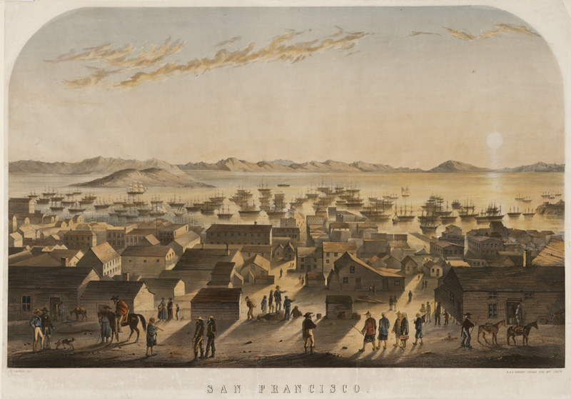
TOP PHOTO: San Francisco [graphic] / S. F. Marryat, delt. (State Library Image 2001-0018_000009835)